When I left Tonopah, I had a 6 hour drive to my aunt’s house in Sonora California. It was beautiful weather and I was going to be passing through Stanislaus National Forest. This was going to be an awesome ride. Which I really needed after my journey across Nevada.
Hawthorne Nevada
Before I embarked on this journey, I didn’t realize how many military installations we have in the United States. We especially seem to have a lot in the western part of the country. I say this because I passed through Hawthorne Nevada on this leg of the trip. As you get close to Hawthorne there are hundreds of these little quonset shaped concrete bunkers. They just appear out of nowhere in the fields. Having no idea what the history of Hawthorne was, I had no idea why these bunkers were there. I did some research and found out Hawthorne is a very interesting place.
Hawthorne Army Depot
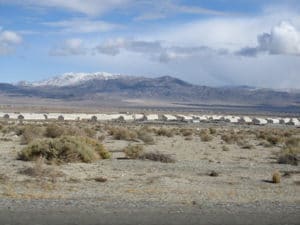
The Hawthorne Army Depot was established in 1930 after a disaster at another depot in New Jersey. The storage depot is directly south of Walker Lake. The depot covers 147,000 acres or 226 sq. mi. and has 600,000 square feet of storage space in 2,427 bunkers. The facility is the “World’s Largest Depot” and is divided into three ammunition storage and production areas, plus an industrial area housing command headquarters, facilities engineering shops, etc. As you drive through town there is evidence of the military history everywhere. Businesses use old, non explosive, bombs as decoration. There is even a Hawthorne Ordinance Museum. As usual I didn’t take the time to stop but I wish I had.
Mono Lake
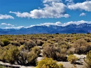
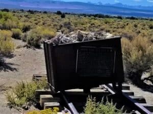
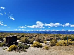 Not long after leaving Hawthorne, I crossed into California and into another one of those places that takes your breath away. Approaching Mono Lake I had to pull over and take pictures. It really is like an oasis in the middle of nowhere. I knew I could not describe the beauty I was witnessing. I needed proof. Unfortunately my pictures didn’t come close to doing it justice. Once again, I just looked from a distance instead of driving the road that takes you right to the lake. I think I am learning a lesson here. Slow down and smell the roses along the way. I had no deadline to be anywhere but rushed anyway. I did stop to check out a monument to the history of the Bodie and Benton Railroad that passed through the area. You can check out the history of the railroad here Bodie and Benton Railroad.
Humboldt–Toiyabe National Forest
After passing by all that beauty, I was greeted with miles and miles of ever increasing beauty. I really am grateful for the idea that was hatched many years ago to save beautiful places for us to explore. Before getting into Stanislaus National Forest, I had to pass through a small part of the 6.3 million acre Humboldt–Toiyabe National Forest. It’s size makes it the largest national forest in the lower 48 states.
The lands now part of Humboldt-Toiyabe have been administratively reorganized many times, and include parts of several defunct national forests. The oldest of these is Ruby Mountains National Forest, established on May 3, 1906. In 1908, it was combined with Independence National Forest to form Humboldt National Forest. Toiyabe National Forest was established March 2, 1907. It ceased to exist in 1932, when it was absorbed by Nevada National Forest, but was reestablished in 1938 from parts of Humboldt and Nevada. The last major reorganization occurred on October 1, 1957, when Nevada National Forest was dissolved and its lands divided between Humboldt and Toiyabe.
Humboldt and Toiyabe National Forests were administratively joined in 1995. Though managed as a single entity, the two forests remain legally and geographically distinct.
Mountain Warfare Training Center
Another surprise discovery in the Humboldt–Toiyabe National Forest is the Marine Corps Mountain Warfare Training Center. I came around a corner and sitting not too far from the road was coast guard helicopter. This was another moment I wanted to stop and take a picture. Judging by all the cameras and barbed wire fence, it didn’t seem like a good spot to just pull over and start snapping pictures haha.
Located in Pickel Meadows on California State Route 108 at 6,800 feet ]above sea level, the training center exists to train units in complex compartmented terrain. The Mountain Warfare Training Center is one of the Corps’ most remote and isolated posts. The Center was established in 1951 as the Cold Weather Battalion with a mission of providing cold-weather training for replacement personnel bound for Korea. After the Korean War, in 1963, the school was renamed the “Mountain Warfare Training Center” due to its expanded role. During the 1980s, the Training Center’s focus was on training and preparing Marines and operational units for deployments on NATO’s Northern flank, particularly Norway.Recently, with the Global War on Terrorism, the MWTC provided pre-deployment training in support of Operation Enduring Freedom—the war in Afghanistan.
Stanislaus National Forest

 The forest consists of 898,099 acres of land in four counties in the Sierra Nevada in Northern California. Having been established on February 22, 1897, it is one of the oldest national forests. The name comes from the Stanislaus River. There are 78 lakes, and 811 miles (1,305.2 km) of rivers and streams within the forest. A network of paved and unpaved roads also exist with 1,100 miles of non-motorized trails, and 2,859 miles of roads, 188 miles of which are paved.
Uses of the Forest
The proximity of the Stanislaus National Forest to the San Francisco Bay area makes it a popular recreation destination. The volcanic and granite formations in the wilderness exist alongside heavy cattle grazing, a shock to many backpackers. Whitewater rafting and kayaking can be found in the wild and scenic Tuolumne River and Cherry Creek. Other rivers flowing out of the Stanislaus include the Clavey River the Stanislaus River, and the Merced River along the southern boundary. Two ski resorts, Dodge Ridge and Bear Valley, operate here under a special use permit.
Driving through the forest
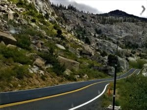
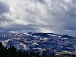
I got a little worried when I saw snow right at the same level I was driving. I know that when snow comes they sometimes close the road. It started spitting snow a couple of times but never amounted to anything serious. The mountains were unbelievable. They rose so high above my van it was hard to see the top. It made me want to climb them but looking at the loose rock. I’m not sure it would be a good idea. The road it very slow and windy.. You have to be on your toes to make sure you don’t get out of control or in the other lane. I am pretty sure my brakes got a serious workout on this stretch. After dodging the snow I started to recognize where I was. Thanks to my Aunt and Uncle who had shown me around area, I knew I was in Mi-wuk village. If you drive through the village stop at Diamond Jims, Jim is an awesome guy and has a great bar/restaurant!
Yosemite and Miwuk History
On a side note, did you know that the Miwuk tribe was kicked out of their lands to establish Yosemite National Park? I had no idea until I actually talked to a person of Miwuk heritage while I was in the park. Thankfully that mistake is starting to be reconciled with a 30-year agreement that would allow the local American Indian Council of Mariposa County to build and use a wahhoga, the Miwuk word for village. A roundhouse is scheduled to be completed in 2019, and multiple umachas—lodges sheathed in cedar bark—will be built as well. The buildings will be constructed using traditional methods and materials and will serve as a focal point for Native American cultural and religious ceremonies. You can read more about that from Outside Magazine here: Yosemite Finally Reckons with Its Discriminatory Past
Until Next Time
After passing through the village I knew I was home free. My mind was swimming with all that I had just seen. I couldn’t wait to tell my tales to my Aunt and Uncle as soon as I arrived. I think that is what I miss most on these long trips, I don’t always have someone to share it with. I am hoping to remedy that situation someday but I guess I need a rich benefactor first haha. Until next time, be on the lookout for more tales from the road on the #payitforwardtour.

Leave a Reply